Lorem ipsum dolor sit amet, elit eget consectetuer adipiscing aenean dolor
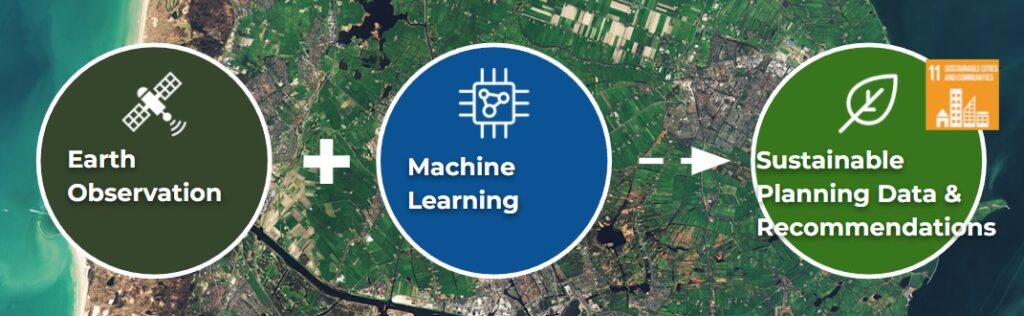
SmartLander: EO + Machine Learning for SDG11
A start-up Earth Observation project to support sustainable urban developments
As a team of five we came together for the 2019 Copernicus Hackathon and continued developing the winning project SmartLander for nine months afterwards.
Planning for sustainable megacities of the future is a complex, time-consuming task. Identifying sustainability risks is currently based on very little data and research. Our solution identified how to easily provide guidance to avoid disasters or preventable breakdown of urban sustainability such as floods, heat islands, poverty within cities, environmental disasters and more.
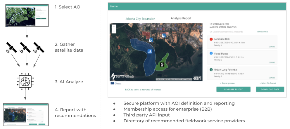
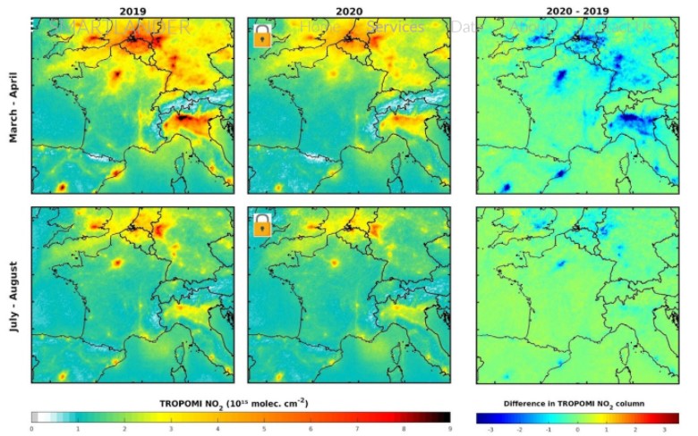
Working on flood defences of megacities can take a GIS analyst 3 weeks to gather, analyze and interpret the connection between other inundations to the one they are assessing. Our approach cuts the time from weeks to minutes with an AI assistant, AND detect patterns that pose a threat to long-term sustainability that are invisible to us.
We bring the power of GIS/Earth Observation + AI and Machine Learning to radically shorten the time it takes to analyse large areas of terrain, providing quick and easy access to environmental officers, policy makers, land developers, scientists and anyone who needs a look into the environmental future of a specific area.
We drove this project through the PLNT Venture Academy (Leiden) and the SBIC Noordwijk IGNITION program, to develop a solid business offering and provide value to future customers.
Environmental sustainability analysis by satellite
Our project identified how to provide environmental and sustainability GIS data for use in urban master planning, environmental impact and sustainability studies of urban and civil mega-projects, using Big Satellite Data to identify risks to urban resilience and sustainability in real time.
This solution provides tools for data-driven decision-making for the sustainable cities of tomorrow. It provides a view of any are of focus integrating its historical data and future forecasts, while providing easy access to Big Satellite Data analysis. It can track water and air quality and composition, land usage, soil composition and density, infrastructure and civil works, temperature variation and more, to gather a full picture of large areas of land that are otherwise impractical to track and discover patterns that are impossible to identify without the combination of Space technology and Machine learning.
Urban Sustainability Risk Report
This report focuses on the risk indicators of your choice in any area in the world, taking into account the specific climate and topographic data of your area, to highlight risks that may prevent making cities and human settlements inclusive, safe, resilient and sustainable. We can capture data such as air quality, green cover, land usage and more, to provide data-driven decision- making during the planning stage, so these can be minimised.
Land impact and water quality near oil and gas facilities
Monitor the impact on your land and water from oil and gas pollution:
– Get an instant pollution report of any property area
– Be warned when levels increase above certain tresholds
– Monitor your area of interest for pollution
Identification of abandoned property
Abandonment of large property* use that has interest to potential buyers, sellers and brokers. Find properties that have become recently abandoned and receive a report with large tourist, farm and real estate properties before they even hit the market!
– Find large locations with unusually low activity
– Set up alarms for when specific locations reach low activity
Locations running high-temperature operations
Monitor the impact on your land and water from oil and gas pollution:
Get an instant pollution report of any property area
Be warned when levels increase above certain tresholds
Monitor your area of interest for pollution
Automated monitoring, tracking and analysis support
Our solution can monitor changes over time in the topography, environment, climate and built structures over the area of your choice, to check how everything is progressing.
We are happy to discuss what your needs are and ensure our monitoring is adjusted to the frequency and detail you need. We remove the barriers to successful geospatial monitoring by providing a vast selection of options to track, to provide the forecasting and/or monitoring insights you need across all kinds of indicators. We can set-up specialized solutions to:
Assess environmental indicators for large-scale civil works
Detection of newly constructed buildings and structures
Tree and green cover detection
3D Elevation
… and more.
Satellite Data analysis can observe and analyze important parameters for sustainability.
For example:
Land Use & Consumption
Public Space/Recreational Use/Open Space
Length of Roads/Area Under Paved Roads (current)
Population Density
Transportation networks
Water (location, quality, etc)
Soil Moisture Content, Wetlands Monitoring
Precipitation
Air Quality
Temperature/Heat Islands
Energy Access/Electrification
Atmospheric Carbon Concentration
Flood Monitoring
Drought Monitoring
Surface Temperature
Critical Infrastructure
The team was formed by Marco A Morales(BA Comm Design) as Product Manager and COO, Manuel Sanabria(Msc. GIS, Bsc. Environmental Science) GIS specialist and Agile coach, Harmen van Oosten (Bsc. Land and water mgmt., Msc. Topografia, Cartografia y Geodesia) on water & land mgmt and Mahabir Gupta (Msc. Computer Science) on GIS, ML/AI and Data Science integration.